

UAV drones obstacle avoidance technology analysis
Time: 2025-04-01 12:20:52
Author: Peter
Click:
Here's the UAV obstacle avoidance technology analysis, optimized with key techni
Here's the UAV obstacle avoidance technology analysis, optimized with key technical terminology and structural clarity:
I. Core Technologies & Principles
- Sensor Technologies
- Ultrasonic: Measures distance via sound wave reflection (0.2-5m range), cost-effective but susceptible to airflow and material interference.
- Infrared: Detects obstacles through infrared light reflection, ideal for short-range (<10m) but vulnerable to sunlight interference.
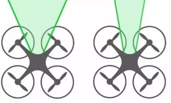
- Binocular Vision: Emulates human stereoscopic vision using dual cameras to generate depth maps (e.g., DJI Phantom 4), achieving cm-level accuracy.
- LiDAR: Creates high-precision 3D point clouds via laser scanning, suitable for complex environments despite high cost and bulk.
- Algorithm Support
- SLAM: Real-time environmental mapping combined with visual/LiDAR data for dynamic path planning.
- Deep Learning: Enables obstacle classification (e.g., distinguishing wires vs. trees) and improves adaptability in complex scenarios.
II. Obstacle Avoidance Workflow
- Environmental Perception: Multi-sensor data fusion (e.g., DJI FlightAutonomy combines binocular vision, ultrasonic, and IMU).
- Data Processing: Noise filtering (Kalman filter) and multi-source data fusion.
- Path Planning
- Global planning: GPS-based route generation.
- Local planning: Real-time adjustment via A*/RRT algorithms.
- Control Execution: Flight attitude/speed regulation using PID or Model Predictive Control (MPC).
III. Industry Challenges & Trends
- Current Limitations
- Delayed response to dynamic obstacles (birds, vehicles).
- Visual system degradation under extreme weather/lighting.
- Future Directions
- Multi-modal Sensor Fusion: LiDAR + vision + mmWave radar for all-weather reliability.
- Swarm Coordination: Distributed decision-making via 5G-enabled data sharing.
- Edge AI Chips: Lightweight processors (e.g., Horizon J5) for real-time computation.
IV. Application Cases
点击右上角
分享给朋友吧







 Long by picture save/share
Follw us
点击右上角
分享给朋友吧
点击右上角
分享给朋友吧
Copyright © 2021-2025 INTCON Ltd. All Rights Reserved.
